Tucked away in the southeastern pocket of Bangladesh, the Chittagong Hill Tracts is an area comprising the three distinctly hilly districts of Rangamati, Khagrachhari, and Bandarban. This area is home to more than one-third of Bangladesh’s total forestland, 80% of national biodiversity, and the largest concentration of Indigenous peoples, who inhabit 12 socio-culturally distinct communities.
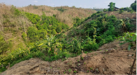
About two-thirds of the Chittagong Hill Tracts' rural households depend on agriculture-related activities, which contribute to 50% of annual net income. On the hilly slopes that characterize the area, local communities employ a traditional agricultural practice known as Jhum cultivation – also known as “slash and burn” or “shifting cultivation.” Jhum cultivation is cyclical in nature; all standing vegetation on a hillside is initially cleared, then burned, with the residual ash acting as natural fertilizer. The area is then sown with a variety of seeds including rice, corn, and legumes. Once the crops are harvested, the jhum area is left fallow to allow the soil to recuperate.
The Nexus of Agricultural Expansion – Biodiversity Loss – Land Degradation
In the Chittagong Hill Tracts, approximately 60,000 households 18% of households -- are traditional practitioners of the jhum method. Mong Ching Way is one such jumma. A member of the Marma peoples, Mong Ching has lived her entire life in the hills of Bandarban, self-sufficient from her surrounding environs that have provided her with shelter, food, and traditional medicines. She worships this hilly region with gratitude and a profound spiritual connection, much like her ancestors. As far back as her memory serves , her livelihood has depended on jhum. Every season she sows seeds, waits another season for them to grow, keeps what she needs for her family, and sells the rest for income.
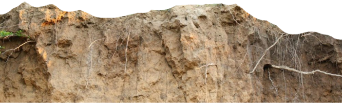
As Mong Ching’s family grew over time, so did the number of more mouths to feed. At the same time, the nature surrounding her family gradually became less and less dependable. Once characterized by picturesque hills and valleys, pristine tropical forest, and diversified flora and fauna, the landscape surrounding the Chittagong Hill Tracts began to change – and degrade – coming under strain amid a growing population and uncontrolled land use change. In fact, the Chittagong Hill Tracts lost at least 56,000 hectares of its net tree cover between 2000 and 2020.
For jummas like Mong Ching, the fallow period is the most important part of shifting cultivation. For centuries, this period ranged from 10 to as many as 15 years, giving the land enough time to regain its fertility. With evolving environmental challenges plaguing the Chittagong Hill Tracts, the fallow period now averages just 3 years – though often much less. This significant decline in the fallow period has brought new challenges to the surrounding nature, including soil nutrient deficiency, microorganism loss, organic matter depletion, excess top-soil runoff during rainfall, and groundwater reduction. Previously, 15-20 crops could be grown together in a jhum field; now, the productivity is limited to 5-8 crops. Cotton and sesame were once valuable cash crops but have gradually declined in recent years due to less productive soil.
Another destructive agricultural practice is large-scale tobacco cultivation in the valleys and moderately slope hill areas. Although lucrative for the farmers, it exploits soil fertility and causes difficulty to grow other crops on the same land. Moreover, tobacco leaf processing requires a large amount of fuelwood (13-14 tons per hectare of tobacco leaves) that comes from the surrounding forests. Now about 22% of the area in the Chittagong Hill Tracts is under tobacco cultivation.
Unsustainable cultivation practices such as these lead to drastic ecological and socio-economic consequences. In the Chittagong Hill Tracts, annually 40-45 tons of soil per hectare is eroded annually due to shifting cultivation. This soil then loses its binding capacity, which increases vulnerabilities to landslides and other environmental risks. Many of the native tree species and diverse ecosystem services provided by the forests have been declining over the years. Potable water is also impacted as streams and creeks are major sources, which get blocked off due to the land degradation, especially in the drier winter seasons. Though agricultural interventions can provide subsistence to the local community in the short term, its impact on biodiversity, soil fertility, and the overall ecosystem health jeopardizes the long-term viability of achieving the district’s economic, social, and environmental goals.
The Way Forward: Integrated Land Use Plan for Sustainable Landscape Management in the Chittagong Hill Tracts
There is no straightforward remedy to rectifying the situation. Political unrest, security concerns, and misalignments between community and government approaches have been major barriers to undertaking a program to restore the degraded landscapes while finding solutions for communities to develop. For communities, one concern is that the short-term yields brought in from such economic activities can outweigh the long-term environmental risks associated with lower productivity. A long-term vision coupled with political commitment, inter-institutional coordination, resource allocation through participatory planning, and legislative support is needed in order to transform livelihoods in the region. One method that can make headway toward a nature-resilient future for the people of the Chittagong Hill
Tracts is an integrated land use plan. This goes beyond an approach that focuses solely on increasing tree cover without addressing ecological functionality and important socioeconomic considerations. Instead, biodiversity conservation, sustainable land management, clear benefit sharing arrangements, community development, and climate change adaptation practices would all be thoroughly considered. The planning method includes four main steps:
- identification of planning objectives;
- assessment of the current situation, gaps, and conflicts;
- an integrated planning and negotiation process; and
- the development of recommendations for establishment of an implementation mechanism.
In view of the challenges facing the people and the environment in the Chittagong Hill Tracts, the World Bank, through PROGREEN, and Arannayk Foundation are working together to develop an integrated land use plan for the sustainable landscape management of the Reinkhyong Reserved Forest (RRF) and the surrounding buffer areas. The primary goals of the proposed management plan are to restore the ecosystem functionality of the degraded landscape and to improve the livelihoods of the local communities while maximizing climate change resilience.
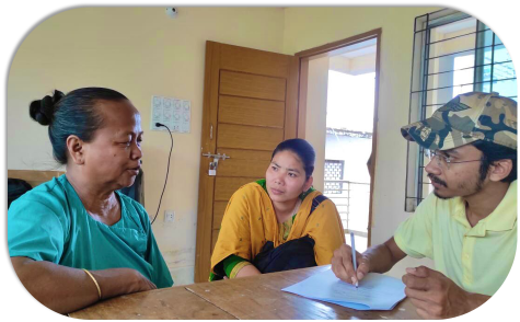
This partnership supports a sound technical assessment of the ecological and socioeconomic needs, and a participatory planning process. To validate the plan, multiple consultations were held with local community representatives (headmen and karbaries), Bangladesh Forest Department officials, regional and district Council authorities, and representatives from NGOs and academia. The planning process informs a strategy that balances and prioritizes the various environmental, social, and economic needs of the people and the environment. Through a combination of data and analytical tools, targeted sustainable land use practices are prescribed for each land class.
Under this plan, more than 38,500 hectares of land is expected to be ecologically improved or shifted to sustainably productive land over the period of 10 years. Sustainable landscape management will allow for higher productivity of land, increasing income generating opportunities for surrounding communities. Beyond income generation and other livelihood impacts, implementation of the plan is expected to lead to additional carbon sequestrations of up to 798,400 tCO2-e in a 20-year span, contributing to both climate change mitigation and adaptation. The benefits and return on investment would essentially be greater than what is measured, as several expected benefits such as biodiversity conservation, wildlife habitat restoration, reduced vulnerability to landslides, and increased groundwater and waterflow are difficult to capture in economic terms.
This sustainable landscape management plan offers a roadmap by which the World Bank can work hand-in-hand with local communities, civil society, and government to restore ecosystems, improve livelihoods, and lay the foundations for climate change resilience.